

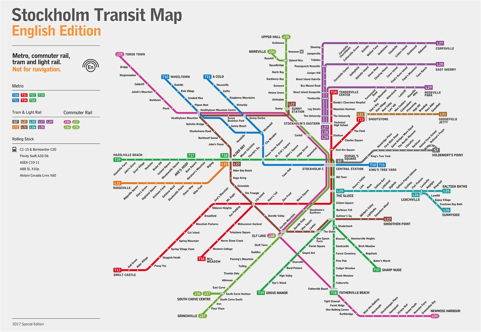
You can find on this page the Stockholm metro map to print and to download in PDF. The Stockholm metro map presents the network, zones, stations and different lines of the metro of Stockholm in Sweden.

The Stockholm metro map shows all the stations and lines of the Stockholm metro. This metro map of Stockholm will allow you to easily plan your routes in the metro of Stockholm in Sweden. The Stockholm metro map is downloadable in PDF, printable and free.
The Stockholm metro (Swedish: Stockholms tunnelbana) is a metro system in Stockholm, Sweden. The first line opened in 1950, and today the system has 100 stations in use, of which 47 are underground and 53 above ground as its mentioned in Metro map Stockholm. There are seven metro lines numbered from 10 to 19, in three groups identified by a color: the Green, Red and Blue lines. Each color line has two or three numbered lines on shared sections through the Stockholm City Centre.
There are 100 stations in use in the Stockholm metro as its mentioned in Metro map Stockholm. One station, Kymlinge, was built but never taken into use. One station has been taken out of use and demolished. The Bagarmossen old surface station was demolished and replaced with a new underground station there instead, this prior to the metro extension to the Skarpnäck metro station.
In 1877, the first public transport was introduced in Stockholm with trams pulled by horses. From 1901, trams were powered by electricity. In 1931, construction of the metro started in Södermalm (see Metro map Stockholm). A tunnel of 1.37 km was dug between Slussen and Ringvägen. Three years later, trains were running. In 1943, the metro was extended west towards Alvik.
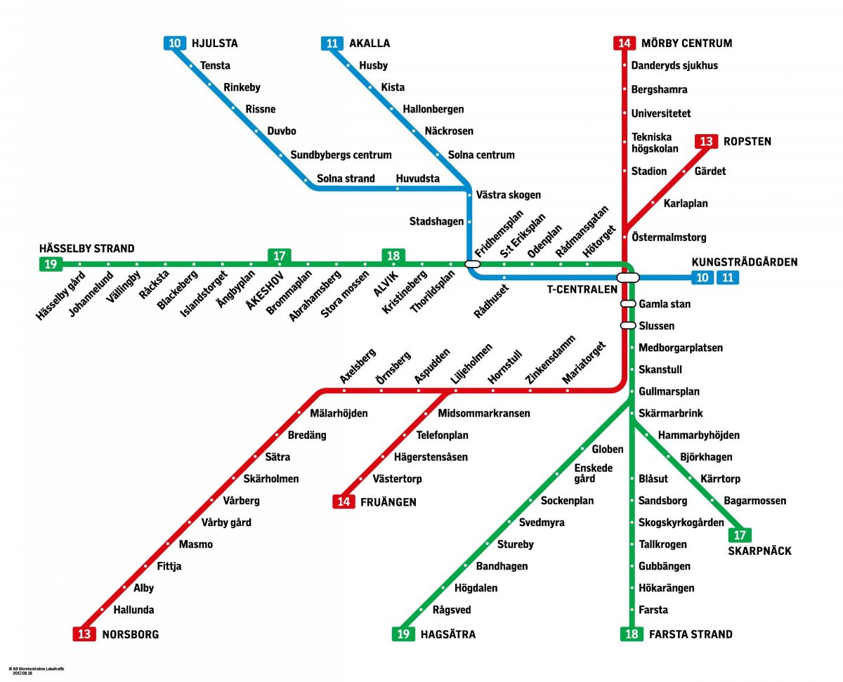
The Stockholm subway map shows all the stations and lines of the Stockholm subway. This subway map of Stockholm will allow you to easily plan your routes in the subway of Stockholm en Sweden. The Stockholm subway map is downloadable in PDF, printable and free.
Stockholm extensive underground network, known as the tunnelbana, is made up of three colour-coded lines (green, red and blue as its shown in Stockholm subway map), which split into different branches on the outskirts of the capital. Subway trains typically run between 5am and 1am during the week and there are through-the-night services on Fridays and Saturdays—very handy in a city where taxis are expensive.
The Stockholm subway is well known for its decoration of the stations; it has been called the longest art gallery in the world. Several of the Stockholm subway stations (especially on the Blue Line as its mentioned in Stockholm subway map) are left with the bedrock exposed, crude and unfinished, or as part of the decorations. At Rissne, an informative wall fresco about the history of Earth civilizations runs along both sides of the platform.
Three main subway lines (red, blue and green) serve the entire region around Stockholm, all running north to south. These subway lines all travel through Stockholm central station “T-Centralen” and transfer to one another at different points marked on the Stockholm subway system map, visible within each metro car. The Green line (officially Tunnelbana 1, or "Metro 1") has 3 line numbers and 49 stations: 12 subterranean (nine concrete, three rock) and 37 above ground stations (between Slussen and Hökarängen stations). The Red line (Tunnelbana 2) has 2 line numbers and 36 stations: 20 subterranean (four concrete, 16 rock) and 15 above ground stations. The Blue line (Tunnelbana 3) has 2 line numbers and 20 stations: 19 subterranean (all rock) and one elevated station.