

You can find on this page the Stockholm airports map to print and to download in PDF. The Stockholm airport map presents terminals and gates of the international airport of Stockholm in Sweden.

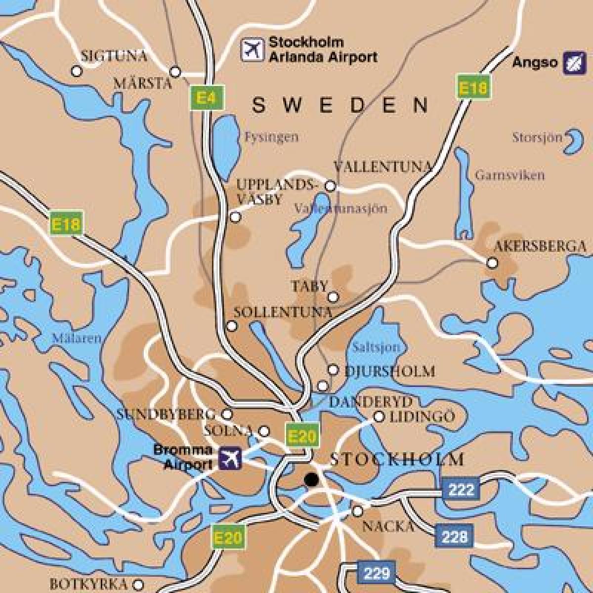
The Stockholm airports map shows all the airports around Stockholm. This airports map of Stockholm will allow you to determine which airport you will used to leave Stockholm in Sweden. The Stockholm airports map is downloadable in PDF, printable and free.
International and domestic: Stockholm-Arlanda Airport (IATA: ARN, ICAO: ESSA) is the largest and busiest airport in Sweden with 18 million passengers in 2007. It is located about 40 km north of Stockholm and serves as a hub for Scandinavian Airlines as you can see in Stockholm airports map. Stockholm-Bromma Airport (IATA: BMA, ICAO: ESSB) is located about 8 km (5.0 mi) west of Stockholm.
Only international: Stockholm-Skavsta Airport (IATA: NYO, ICAO: ESKN) is located 100 km (62 mi) south of Stockholm as its shown in Stockholm airports map. Stockholm-Västerås Airport (IATA: VST, ICAO: ESOW) is located 110 km (68 mi) west of Stockholm, in the city of Västerås. As of 2010 there are no airports specifically for general aviation in the Stockholm area.
The four airports of Stockholm serve more than 30 million passengers annually and they represent main airline connection to countries surrounding the Baltic Sea. There are several ways of reaching Stockholm city from all four airports as its mentioned in Stockholm airports map. Arlanda Express airport rail link runs between Arlanda Airport and central Stockholm. There are also bus lines, Flygbussarna, that run between central Stockholm and all the airports.

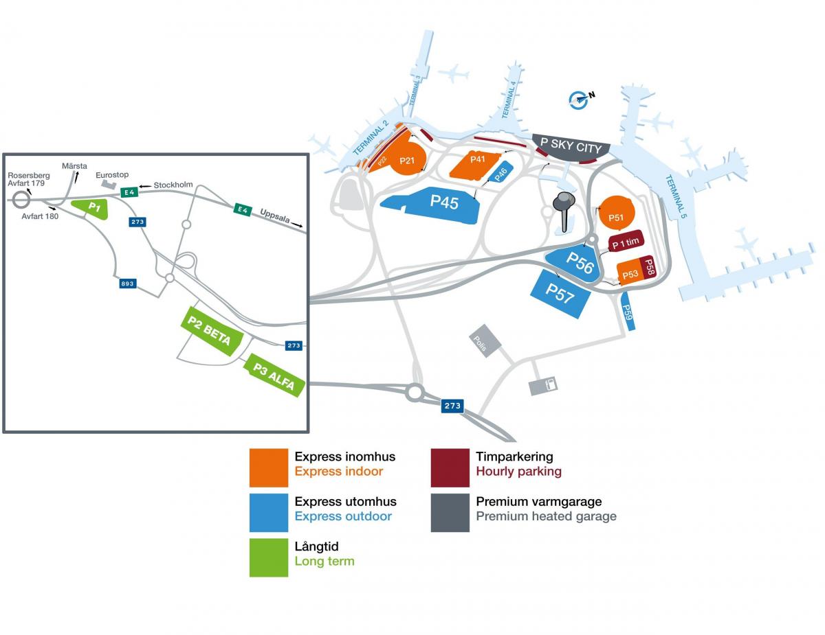
The map of Stockholm airport presents the main international airport of Stockholm. This international airport map of Stockholm will allow you to determine by which terminal and gate you will arrive or leave Stockholm in Sweden. The airport Stockholm map is downloadable in PDF, printable and free.
Stockholm international airport has four terminals. Terminals 2 and 5 are used for international flights. Domestic flights are in Terminals 3 and 4. The new central building, Arlanda North, opened late 2003, connecting terminal 5 with the newly built Pier F. All international flights handled by SAS and its Star Alliance partners use the new central building as you can see in Stockholm international airport map. An Arlanda South building, connecting terminals 2, 3 and 4, was also planned, but construction is currently suspended due to lack of funds.
Stockholm international airport has three runways: Runway 1 (01L/19R), Runway 2 (08/26), Runway 3 (01R/19L). Runway 1 is 3,301 m (10,830 ft) long and can handle take-offs and landings of the heaviest aircraft in use today. Runways 2 and 3 are 2,500 m (8,202 ft) long as its shown in Stockholm international airport map. As indicated, runways 1 and 3 are parallel runways that can be operated independently of one another. Runway 3 is equipped with CAT III for instrument landings.
The parking facilities at Stockholm international airport are good, though it can be difficult to keep an overview given the many options available. At Terminal 2, Terminal 3 and Terminal 4 you can find car parks P21, P22 and P41 as well as outdoor parking lots P45 and P46 as its mentioned in Stockholm international airport map. At Terminal 5, parking is possible inside car parks P51 and P53 as well as outside on parking lots P56, P57 and P8.